
K37 - Around Begunjščica: Preval, Zelenica
One of the most challenging routes in the Tržič area
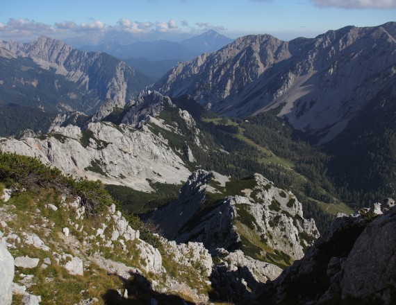
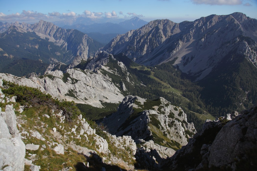
Begunjščica, like other peaks in the Karawanks, shows two completely different faces: the southern slopes are grassy and sunny while the northern ones are rocky and shaded. Along this challenging route with 1750 meters of elevation change you will first encounter the more friendly southern part while in the second part of the route you will be glad to reach the warm shelter of Zelenica Mountain Hostel and know that ahead of you is a fantastic descent along the Border Patrol Trail.
 1 / 8 K37 - Around Begunjščica: Preval, Zelenica
-
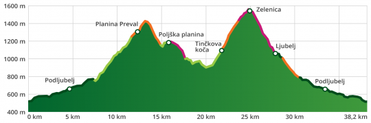
type of path: mountainbike length: 38 km / 6.5 h elevation change: 1.750 m difficulty: ***** - technical: **** - condition: ***** panorama: *****


route
Tržič–Podljubelj–Preval pasture–Poljška pasture–Tolsti Vrh–Završnica Valley–Smokuška pasture–Zelenica–Ljubelj–Tržič
ROUTE DESCRIPTION
The starting point for cycling tours is in the city centre, opposite the Tržič bus station. Parking is possible in public parking areas (parking lots at the Municipality of Tržič, on Predilniška Road at the entrance to the city-BPT, at the Tržič Olympians Hall, along the street Za Mošenikom, among others).
In Tržič, head north through the town centre in the direction of Podljubelj. At the intersection at the top of the hill, where the main road begins to descend towards Ravne, keep right towards Podljubelj. Ride past the Mošenik power station, across the overpass above the main road to Podljubelj, and through the village. Follow the side road past the Školjka Bistro to Lajb, where you will turn left before a large abandoned restaurant and cross the overpass above the main road. Follow the gravel road, which leads past some houses and goes first downhill, then after 250 metres begins to climb towards Preval mountain pasture. In the lower part you will be located in the area of the former cinnabarite and mercury mine. Anton’s Shaft is open to visitors, and a tour can be arranged by prior appointment at Tržič TPIC. Ahead of you are 4.4 km and 550 metres of ascent, which fortunately runs through a fairly well-shaded valley. At an elevation of around 1,240 metres, where the road crosses the riverbed and levels out somewhat, be careful not to miss the turnoff that leads steeply uphill to the right, as this singletrack trail will take you to Preval mountain pasture.
Take a break for rest and refreshment and enjoy the beautiful view of Begunjščica above you, Košuta to the east, and the Julian Alps to the west.
Continue along a poorly maintained road along the slope, along which you will ascend another 100 metres to the source of the Roža stream, followed by a steep descent towards Planinca mountain pasture. Here, at the crossroads, turn right towards Poljška mountain pasture. A singletrack trail will take you along the ridge, which turns into a very nice trail and begins to descend into the Završnica Valley. The last 200 metres of the trail is quite steep and technically fairly demanding, so walking your bike is recommended. At the Kališče Saddle you will reach the road. Here you turn right and descend another 2.5 km to the Završnica Valley. When you reach the intersection with the main road, turn sharply right. Ahead of you is a bit less than 5 km and 650 metres of ascent past the hut Pri Žagi, Tinčkova Hut, Smokuška mountain pasture and the hut at the source of the Završnica to Zelenica. The section from Tinčkova Hut on is difficult to bike due to the steep and poorly maintained road.
At Zelenica Mountain Hostel you can treat yourself to a longer rest, as there is only a descent ahead of you. Descend towards Ljubelj along the service road; descent along the technically challenging Border Patrol Trail (variant 37a) is advised only for highly experienced cyclists. From Ljubelj descend partly along the main road, partly along side trails to Lajb, and from there along the local road to Tržič.
good to know
The route is long and physically demanding, suitable only for mountain bikers who are quite fit. You can start in Podljubelj or in Lajb and thus skip the paved part between Tržič and Podljubelj.
Maps
- Karawanks - central part, 1:50 000, PZS
- Stol, 1:25 000, PZS
Rules of the trail for mountain bikers

Please note: The content provided on this site is for informational purposes only. Paths, trails, and roads in natural areas are not signposted. Cycling is permitted on roads and forest roads unless explicitly prohibited. Cycling along logging skid trails, hiking trails, and other footpaths is prohibited unless explicitly allowed. Where cycling is prohibited, cyclists must dismount and continue on foot. Tracks in the .gpx format are for informational purposes only and are meant solely as an aid; they do not necessarily mean that cycling is allowed. Visitors cycle at their own risk.