
K34 - Up and down around Dobrča
Physically very strenuous, this is one of the longest but also more interesting routes in Tržič.
Dobrča is well known not only to hikers but also to mountain bikers as well as to paragliders, who catch the thermals on its southern slopes. Although this route does not take you up to the top, you will ride around the mountain and by the end of the route there will be an elevation change of 1.300 metres behind you.
 1 / 3 K34 - Up and down around Dobrča
-
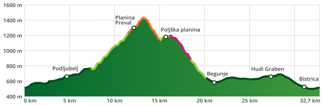
type of path: mountainbike length: 33 km / 5 h elevation change: 1.300 m difficulty: ***** - technical: **** - condition: ***** panorama: ****


route
Tržič - Podljubelj - Preval pasture - Poljška pasture - Smokuč- Begunje na Gorenjskem - Hudi Graben - Tržič
ROUTE DESCRIPTION
The starting point for cycling tours is in the city centre, opposite the Tržič bus station. Parking is possible in public parking areas (parking lots at the Municipality of Tržič, on Predilniška Road at the entrance to the city-BPT, at the Tržič Olympians Hall, along the street Za Mošenikom, among others).
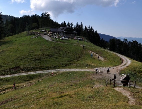
In Tržič, head north through the town centre in the direction of Podljubelj. At the intersection at the top of the hill, where the main road begins to descend towards Ravne, keep right towards Podljubelj. Ride past the Mošenik power station, across the overpass above the main road to Podljubelj, and through the village. Follow the side road past the Školjka Bistro to Lajb, where you will turn left before a large abandoned restaurant and cross the overpass above the main road. Follow the gravel road, which leads past some houses and goes first downhill, then after 250 metres begins to climb towards Preval mountain pasture. In the lower part you will be located in the area of the former cinnabarite and mercury mine. Anton’s Shaft is open to visitors, and a tour can be arranged by prior appointment at Tržič TPIC. Ahead of you lie 4.4 km and 550 metres of ascent, which fortunately runs through a fairly well-shaded valley. At an elevation of around 1,240 metres, where the road crosses the riverbed and levels out somewhat, be careful not to miss the turnoff that leads steeply uphill to the right, as this singletrack trail will take you to Preval mountain pasture.
Take a break for rest and refreshment and enjoy the beautiful view of Begunjščica above you, Košuta to the east, and the Julian Alps to the west.
Continue along a poorly maintained road along the slope, along which you will ascend another 100 metres to the source of the Roža stream, followed by a steep descent towards Planinca mountain pasture. Here, at the crossroads, turn right towards Poljška mountain pasture. A singletrack trail will take you along the ridge, which turns into a very nice trail and begins to descend into the Završnica Valley. The last 200 metres of the trail are quite steep and technically fairly demanding, so walking your bike is recommended. At the Kališče Saddle you will reach a road.
Here you have three options: the basic version takes you directly to Begunje along a steep singletrack trail that goes downhill to the left; the first part (approx. 800 m) is difficult to navigate.
asier descent through Završnica 34a: the road downhill to the right is well maintained and technically not difficult, but somewhat longer: you will reach Begunje through the Završnica Valley and back through Žirovnica.
More challenging descent 34b across Smokuški Vrh: continue up the road, after a short ascent you will reach the end of the road, stay to the right along a narrow trail up towards Smokuški Vrh. The last 150 m is too steep to ride uphill, but it is worth the effort on foot, as Smokuški Vrh offers a beautiful view of the Radovljica Basin, Lake Bled and the Julian Alps in the background. Descend back to the road and continue along the singletrack trail to the right. After 300 m, the trail branches off to the right, after which you descend to a lookout point at the hunting lodge and on towards Sankaška Hut. When you get to the road and holiday cottages, go along the narrow trail to the extreme right. Caution: due to the narrow trail, sand and roots, this part of the route is very challenging, but below it is a beautiful traverse. You will steadily descend the slope to the right; do not be distracted by the several trails that branch off to the left into the valley. The descent ends on a small hill above Smokuč, where you prepare for the return. Traverse to the left for another 500 m over the meadows above the village, then descend along the road to Rodine and left towards Begunje.
In Begunje na Gorenjskem, follow the main road and the signs towards Tržič. A bit over 12 km of riding remains, with an ascent of about 150 m and then a descent through Brezje pri Tržiču and Bistrica pri Tržiču back to Tržič.
Maps
- Karawanks - central part, 1:50 000, PZS
- Stol, 1:25 000, PZS
Rules of the trail for mountain bikers

Please note: The content provided on this site is for informational purposes only. Paths, trails, and roads in natural areas are not signposted. Cycling is permitted on roads and forest roads unless explicitly prohibited. Cycling along logging skid trails, hiking trails, and other footpaths is prohibited unless explicitly allowed. Where cycling is prohibited, cyclists must dismount and continue on foot. Tracks in the .gpx format are for informational purposes only and are meant solely as an aid; they do not necessarily mean that cycling is allowed. Visitors cycle at their own risk.